

When he was 48, Mark Twain recorded his fear of this stretch as a young river pilot in training in Life on the Mississippi, published by James R. Osgood & Co., 1883. Many years later, Twain recalled the submerged terrors of the Grand Chain with dread. Twain’s steamboats are gone now, but the Grand Chain’s rocky reefs still wait to pierce and slice keels of all kinds. The Chain’s pinnacles are the hard rock siblings of Titanic’s iceberg, dumb but deadly. When the river gage is normal or high they are of little concern to river traffic, but when the river gage drops to near zero at Thebes, they become very hazardous. People who sit safely ashore seldom hear of river pilots’ safety concerns about towing barges through the Chain, but the concern is there for every pilot and for the U.S. Army Corps of Engineers (Corps), the people charged with keeping the river safe and navigable.
The Grand Chain is an eight-mile stretch of the river that is floored with limestone ledges, up-thrusting pinnacles and embedded boulders, some weighing as much as 15 tons. The Corps under the leadership of project manager Mike Rodgers and working side-by-side with the U.S. Coast Guard and the River Industry Action Committee (RIAC), has been charged with the responsibility of clearing the channel of the Chain’s hazardous rock pinnacles. Low Mississippi River stages, particularly those as low as experienced in 2013, strain the ability of the Corps to maintain the navigation channel at authorized project dimensions in the eight-mile Thebes Reach (river miles 46-38) and the mile-long Grand Tower Reach (river miles 80-79).
If the water was clear, an overhead view of this area would show a forest of pinnacle rocks crowding the navigation channel on both sides and in some cases popping up within the channel. Figure 2 provides a red-green bathymetric view at river mile 38.5, showing the rocks in red and the water in green. Figure 3 provides a cross-sectional view at this same river mile, showing that when the Thebes river gage is at zero, rock pinnacles protrude 1 ft above the bottom of the low water channel. The Corps has to fix that problem by removing the pinnacles.
The Corps has a difficult management task. Their construction company cannot work when the water is too high. Also, the work is coordinated to mitigate closures and restrictions during the peak shipping season, and they have to stop construction work when the endangered pallid sturgeon is laying eggs. The Corps also has to worry about obtaining funding, which is not only difficult but can be extremely tricky to fit into their short schedules. Recent work has been divided into two phases. Phase 1 has been completed.
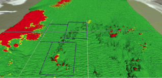
Figure 2: Red-green bathymetric view of river bed at river mile 38.5 south of Thebes, Ill.
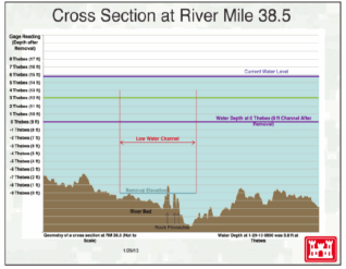
Figure 3: Cross-section of Mississippi River bed five miles south of Thebes, Ill.
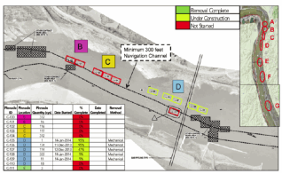
Figure 4: Rock removal scheduled for Phase 2 at river miles 46-43 near Thebes, Ill. (as of 1/14/14).
Removing the pinnacles is a long-term project that started many years ago but resumed in 2012 when a persistent drought dropped river levels low enough to permit the construction work. Phase 1 yielded a 9-ft deep channel in four locations that previously had insufficient depth. The resultant low water channel was only able to safely support a 15-barge tow, so more work is required at these locations to achieve the authorized channel dimensions. Tows of 25 to 35 barges commonly transit this reach during “normal” operations. At low water levels larger tows must “double-trip,” or must break tows apart and take individual pieces through the reach. Phase I was completed on February 27, 2013, at which time 1,000 cubic yards of hard rock had been removed at a cost of $8 million.
Phase 2 Work Begins
The amount of rock removal planned for Phase 2 is shown in Figure 4. Overall, Massman Construction will remove 6,300 cubic yards of rock. Figure 4 shows the base contract for Phase 2, approximately 1,527 cubic yards. Options 1-3 will remove the remaining 4,773 cubic yards. When removed, greater width will be provided in the river bends for mariners to safely navigate the reach. It is located between Thebes (L) and Gray’s Point, Mo. (R). On July 2, 2013, the Corps awarded Rock Removal Phase 2 to Massman Construction for a minimum contract amount of $1 million. It included a base year and three option years for a total contract amount of $19 million. Massman began removal on December 11, 2013. Based on a Cape Girardeau stage of 10 ft or below and a performance period of 150 days, Massman is expected to remove approximately 2,800 cubic yards of rock. The removal timeframe can change due to water levels, environmental conditions and other factors such as ice that can impact construction operations. The performance period of 150 days is for the base and option 1, not the entire project.
The Corps has worked with RIAC and the Coast Guard to minimize the impact of the restrictions, but due to safety concerns, restrictions and closures will occur during hours of construction. Traffic restrictions/closures are occurring at mile 44 in front of the Thebes boat ramp while the contractor is performing Phase 2. Although work began December 11, the contractor has suspended work due to river levels and channel debris (ice) on various occasions. Work is performed Monday through Saturday, 12 to 16 hours a day, depending on weather conditions. While the contractor is working, the current maximum allowable tow size is 25 barges southbound and 36 barges northbound, but this is subject to change based on work locations. There are no restrictions on tow size or traffic while the contractor is not working.
Barge Operations
According to AEP Riverops’ Marty Hettel, barge operators are more concerned right now about ice than they are about rock pinnacles. The flow of ice down the river displaces buoys that mark the channel. Boat groundings continue to occur at miles 50 and 90 in the bends, and delays are mounting as boats are queuing, waiting for the channel to be cleared. As of January 15, recent boat groundings have been cleared along the Upper Mississippi River, but there continues to be quite a bit of channel delay for northbound tows. Tow sizes have been reduced in response to the narrow channel; however, the Corps is resetting the buoys from Cairo to St. Louis. Tow sizes should return to normal after the buoys are reset.
The good news was that warming temperatures and rain forecasts in parts of the Central Midwest were expected to melt the ice, thus allowing the the Coast Guard to re-set the buoys that mark the channel, which should have improved these navigation aids over the next few days in mid-January. In this stretch of the river, AEP Riverops has been running with 25 barges southbound and 36 barges northbound (16 loads and 20 empties), and they are loading to 9 ft of draft. This news is good but a bit tentative, as it is still possible to receive an “Alberta clipper” or two before winter ends.
In the Upper Mississippi River there are several coal docks between Thebes and the mouth of the Illinois River. They include Cora Dock, Kellogg Dock, Cahokia Terminal, Lone Eagle Dock, Hall Street Terminal and a few smaller docks. Cora alone loads 7-10 million tons into river barges; another 3-4 million tons is loaded at Knight Hawk Coal’s Lone Eagle Dock. In 2011, the total of all commodities running north and south in this stretch of the Upper Mississippi River was 106.6 million tons of which 25.6 million tons were coal.
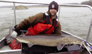
Lead field technician Brad Rogers with a lake sturgeon caught at Chain of Rocks. They caught it on a trot line using night crawlers. (Photo Credit: Ian Kennedy, U.S. Fish & Wildlife Service)
Time Out for Fish and Wildlife
The Carterville Fish and Wildlife Conservation Office (FWCO) is concerned that alterations to the river channel will improve navigation, but may have adverse effects on certain fish species that use these same areas. There are many different types of fish lurking beneath the Mississippi’s turbulent muddy water; the one FWCO is looking for is the endangered pallid sturgeon. Pallid sturgeons can weigh up to 80 lb and reach lengths of 6 ft. Species sampling began on November 6, 2013. Personnel from Carterville FWCO, along with personnel from the Missouri Department of Conservation and USACE worked together to collect channel catfish, blue catfish, shovelnose sturgeon and pallid sturgeon. They also boated four lake sturgeons at Chain of Rocks (Figure 5).
The pallid sturgeon is known to inhabit the main stem Missouri and Mississippi rivers and their larger associated tributaries. In the Missouri River it is found from Fort Benton, Mont., downstream to the confluence of the Missouri and Mississippi rivers at St. Louis, Mo. Pallid sturgeon typically occupy habitats associated with sand, gravel and rock substrates.
Egg-laying typically occurs in the spring to early summer and the eggs are deposited in areas of deep water (deeper than 3 ft) with swift current (faster than 3 ft per second) and typically are laid over or adjacent to gravel, cobble or rock. Construction activities within the channel or adjacent to gravel, cobble, or rock on stabilized banks along the outside bends have the potential to adversely affect pallid sturgeon if the fish are present during construction. Therefore, the last date for conducting the pinnacle removal this season is April 12, 2014.
Dave Gambrel is a professional engineer and former director of transportation for Peabody Coal Co. He covers transportation for Coal Age and occasionally contributes to Engineering & Mining Journal, as well as other transportation-related titles. He can be reached by email at bunkgambrel@earthlink.net