Despite recent news of floods and failures, experts say impoundments built on sound science should weather the storms of tomorrow
by jesse morton, technical writer
They say this year has brought the heaviest monsoon rainfall to parts of India in a quarter-century. Coal India Ltd., the largest coal producer in the world, recently scaled back its production guidance for the year by 2.1% in part because of all the rain. That number made headlines globally but doesn’t come close to telling the story.
A more telling headline comes from the expansive Korba basin in central India. The rains there last month were so heavy the Lilagar River reportedly “changed its course” and entered a surface mine operated by South Eastern Coalfields Ltd. (SECL).
SECL’s Gevra surface coal mine, reputed to be the largest of its kind in Asia, is apparently now a series of connected small lakes. Recent footage shows a sprawling blackwater river, stretching to the horizon and hugging the edge of the pit. In a couple of places it punches through the rim with explosive force, creating torrents that wash away everything in its path. Under gray skies, perched on high places along the rim, listless workers in slickers and curious locals watch the equipment in the pits sink beneath the waters.
And the rain continued.
Such rainfall, in this case 20% more than the normal amount for the timeframe, constitutes what meteorologists call “extreme weather events,” which are occurring with increased frequency due to “climate change,” according to an expert from an Indian governmental natural disaster monitoring agency.
Extreme weather events are the stuff of nightmares for mine managers, especially those with vast and aging tailings impoundments. For one considering building a new dam, they might be even more alarming. And the fear gauge clicks up a notch for both when Reuters reported in October that a Brazil mining regulator closed operations at more than 50 tailings dams due to a lack of stability, the latest development in the aftermath of the catastrophic Brumadinho dam failure.
For many, though, that fear may be irrational, according to a company that specializes in predicting rainfall over time for the purposes of, among other things, designing dams. For those hoping to build a new impoundment, proper engineering can reduce liability and limit the likelihood of disaster, according to impoundment construction experts from SynTerra Corp. For the rest, however, simply assessing existing impoundments and reviewing the rainfall prediction data on which they were based would be the first steps toward restoring peace of mind.

Hurricane Harvey brought record-breaking rainfall. It didn’t however, merit tossing out the existing PMPs for the region, experts say. (Image: NOAA)
Extreme Weather Events
While it churned over Houston, Hurricane Harvey was described by the American press as apocalyptic. Climate change reportedly added a whopping 15% more rain to the Category 4 storm.
Such reporting is par for the course for the mainstream media and often misrepresents the best science on the topic, according to Judith Curry, founder of the Climate Forecast Applications Network and former chair of the School of Earth and Atmospheric Sciences at the Georgia Institute of Technology. In an editorial for the National Review, she reported “(a)ny convincing claim that manmade climate change has altered hurricane activity requires identifying a change in hurricane characteristics that can’t be explained by natural climate variability.”
Previously, in the white paper Hurricanes and Climate Change, Curry pointed out that actual weather measurements show that in many cases warming has been a quarter to a half less than what the models suggested it would be. The models undervalue the cooling effect of what she calls aerosols, airborne particles in the atmosphere. The data shows that actual temps from 2000 to 2012 “are at the bottom of the envelope” of the oft-cited models and predictions. “Recent data since 2012 continues to indicate that the sensitivity of at least some of the climate models to CO2 forcing is too high,” she reported.
Curry reported that in predicting future hurricanes and extreme weather events, natural cooling cycles in the oceans have to be taken into account, as do solar cycles. For instance, after its activity peaked shortly after the millennium, the sun is now cycling down to what is called a solar minimum. And, separately but likely related, at some point, the Beaufort Gyre, a swirling arctic ocean current, will cycle down and start pushing icy cold water southward. Prophecy of a future rife with rainfall doom can’t be said to be based on sound science, she reported.
Nonetheless, Curry told Coal Age that, going forward, natural climate variability could cause changes in trends in extreme weather events. “Global warming,” she said, “whatever the cause, acts toward increasing rainfall.”
The inevitable conclusion appears to be that from here on out, more storms with heavier rainfall can be expected. Suffice it to say, the odds seem long that tailings dams built decades ago were engineered with that future in mind.
But many were, according to Bill Kappel, president and chief meteorologist, Applied Weather Associates (AWA).
In a speech at the Association of State Dam Safety Officials conference in Orlando, Florida, last month, Kappel said climate change, as it is now sold to the public as driven by human activities, is, among other things, a misnomer. Climate has always been changing, he said. It is in a permanent state of flux, and how it changes going forward will affect each place differently. “Context is important,” he said.
Fear not, he said, because most dams built based on probable maximum precipitation (PMP) metrics should be ok.
Tailings dams built based on PMP metrics derived using sound science, in most cases, are likely capable of handling the rains, even extreme weather event rains, that climate change, as it is now preached, will bring, Kappel said.
The key term there is sound science.
“If the PMP was designed using the Hershfield Method, you definitely want to re-look at that and make sure it is adequate,” he said. “Because it is probably not. If your design basis is really old for your PMP, say 30, 40, or 50 years, then, yeah, you want to re-look at it and make sure you are inputting the latest storms and information.”
Which is exactly what AWA was recently contracted to do for both Colorado and New Mexico. It is the company’s main gig, and it has done it for some of the biggest dams and impoundments in North America. Its customers include TVA and Duke Energy, and its findings consistently meet the criteria of the strictest permitting bodies in the U.S. All that would be due to its experience and database. Both now empower it to arrive at scientifically defensible PMP metrics for locales Kappel describes as deficient in historical meteorological data, meaning the boonies, where most new mines will be sited.
Serving the Underserved
Arriving at accurate PMPs for underserved areas can be particularly challenging. That goes for parts of Montana as much as it goes for areas of Mozambique. Historically, operators in such areas would use the Hershfield method to arrive at some critical rainfall prediction metrics, Kappel said.
In a white paper due out soon and provided to Coal Age, Kappel reported the method “is used mostly for making quick estimates for basins of no more than about 400 square miles.” Taking relatively little time, it requires no meteorological expertise. However, “it yields only point values of PMP and therefore requires area-reduction curves for adjusting the point values to basin area sizes,” Kappel reported. “A second problem is in determining the appropriate frequency factor value to use.”
Hershfield method-based PMPs are usually too imprecise for the permitting bodies of today. Its historical widespread usage “is one of the main reasons that more detailed PMP analyses are needed at so many locations,” Kappel reported.
AWA uses a storm-based approach to derive PMP. “Additional meteorological parameters, such as annual exceedance probabilities of PMP, regional precipitation frequency climatologies, and depth-dura-
tion-frequency curves, are also derived” using the same approach,
Kappel reported.
AWA grabs whatever storm data is available for the region. “AWA’s Storm Precipitation Analysis System is used to analyze all storms,” Kappel reported. It data mines them to produce the standard outputs and illustrative grids and maps. “In addition, AWA derives climatological data sets that are used to adjust individual storms,” he said. “These include development of 100-year recurrence interval dew point climatologies, sea surface temperature climatologies, and 100-year recurrence interval precipitation frequency estimates.”
When the area is remote and the data nonexistent, AWA looks for a similar location for which the required data exists. A search domain is set to include areas “similar to the basin in regard to meteorological and topographical environments,” Kappel reported.
AWA “looks for any storm in that overall region,” Kappel said. “We’re talking hundreds of thousands of square miles usually. You analyze the storms there as they occur in place.”
Prime sites are usually those at the same latitude and “influenced by similar topography,” he reported. Interactions of topography and moisture availability are considered. Elevation differences are considered.
The result is climatological data sets that are then “transpositioned” to the region of interest to produce the PMP metrics for it. “The transpositioning process is basically trading time for space,” Kappel said.
The PMP metrics should satisfy most permitting bodies, Kappel said. They should also satisfy the impoundment engineer, who expects more than a handful of numbers.
Among the deliverables AWA provides is the requisite context for the PMP metrics, Kappel said. “It is very important that they understand the context of how those values are derived,” Kappel said. “It has to be a complete picture.”
With all the variables the impoundment engineer has to work with, and with all the liability involved, nothing less than the complete picture will do.

Pittston Coal Co.’s slurry dam No. 3 failed on February 26, 1972, after heavy rains and only four days after it had been approved by a federal inspector. Known as the Buffalo Creek disaster, the resulting flood destroyed more than 507 homes and killed 125 people. (Photo: Coal Age, April 1972)
Erring on the Side of Conservatism
A generation ago, designing, building, managing and monitoring an impoundment dam might have been done entirely in-house. Historically, in a particularly cost-conscious operation, it may have presented as the most profitable path. Advancements in soil sciences and structural engineering over the decades, though, along with some recent disastrous dam failures and the lawsuits that followed, have mostly eliminated the practice.
Charles Bishop, P.E., and Alan Campoli, P.E., Ph.D, SME-RM, impoundment engineers with SynTerra Corp., told Coal Age that rolling with underqualified in-house personnel to save a dime these days could, in the end, land a miner in the slammer and relegate a once-burgeoning company to the tailings pond of history.
“Picture this,” Campoli, geotechnical engineering group leader, SynTerra, said. “You’ve got an engineer. He might be a professional engineer. He might not be. Somehow he arrives at plans for this thing. He’s supposed to be monitoring all the instrumentation. That instrumentation gives you data on the dam structure that requires training and experience few have.”
Stop is a four-letter word at most ops these days, Campoli continued. “When you stop, you’ve got no place to put this waste from the prep plant. And that engineer is under a lot of pressure to say, ok, go ahead and do it. That is exactly what has happened at failures in the past.” Buffalo Creek or even Brumadinho are a couple examples that comes to mind, he said.
The stakes are high. Throw in climate change and the surge in environmentalist zealotry it has fueled even among supposedly level-headed politicians, and they are getting higher. When Bishop and Campoli suggested that jail might be an alternative to not bringing in the pros, they weren’t fear mongering or threatening. They are instead simplifying their assessment of all the work that goes into building an impoundment that will last until the final televised doomsday storm.
Bishop, senior geotechnical engineer, SynTerra, told Coal Age that the expertise required to successfully design, build, monitor and maintain a dam in a flatland region like the Illinois Basin would belong to a geotechnical engineer with no less than two decades of field experience. “They are going to need an advanced degree in geotechnical engineering,” he said. Without a masters or doctorate, “they aren’t going to have the academic knowledge to take and evaluate soft foundation soil conditions impacting embankment stability.”
If they somehow already have the designs in hand, which can span between 10 and 20 drawing sheets, a mining engineer with a bachelor’s degree and a half decade of experience in construction could possibly build the same facility. “They would have to already understand how to monitor the installation, and the compaction of soils as they are put down,” Campoli said.
It is the soft soil conditions and how soft soil consolidates that makes such a project so complex. “In Illinois, you have the potential for deep soils and potentially soft soils, clays, silts, the results of glaciation,” Bishop said. “Soft foundation soils become a real problem with regard to their shear strength and potential for settlement.”
Contrarily, building in the mountains, like Appalachia, presents some challenges but typically of a lesser degree. “In Appalachia, you’ve got thin soils in the hillsides and potentially thicker soils in the valley bottom, which is eroded off the hillside and more granular,” Bishop said. “In the mountains, if there is very much foundation soil in the valley bottom, a lot of times they just go in there, excavate and haul it out.”
Among the early steps taken is what the two referred to as an exploration phase. In the flatlands, it is “tremendously more involved” than it is in the mountains, Bishop said. The checklist includes undisturbed soil sampling, undisturbed strength testing, insitu soil strength testing, lab soil strength and lab physical characteristics tests including multiple geotechnical analyses. The results are crunched to arrive at predictions on “how the embankments are going to perform as they are being loaded,” he said. “Is there going to be a slope stability problem associated with construction? Is there going to have to be monitoring and sequenced construction to avoid a problem?”
For mountainous terrain, “you would do borings in the valley bottom and rock core borings in the hillsides,” Bishop said. “You would be looking at the ratio of coarse reject to fine reject from the plant to come up with your staging,” he said. “Once you have those ratios, you would work out a staging to where the coarse could construct the embankment faster than the fines accumulate in the pool behind it.”
All that would be supplemented by research on the history of the site and surrounding area. Dense, worm-eaten texts journaling the history of various mining companies and found in the bowels of state archive libraries is prime fodder. “There have also been situations where we find the maps from the 1940s and 1950s are historically inaccurate,” Campoli said. “The coal companies cheated and mined more coal than they paid for outside the boundary lines,” he said. “You have to be suspicious.”
Even in locales that maintain thorough online records, “some of the maps may have still been incomplete or not up to date when mining stopped,” Steven Gardner, P.E., SME-RM, SynTerra said. “You do have to be suspicious and look at all possible records.”
The goal is to put together a listing of “all the openings that are in the ground below the impoundment to ensure that they are far enough away or filled properly to prevent instability,” Campoli said. “If you drill boreholes that is one thing, but the boreholes could potentially miss the previous openings from existing mining,” he said. “That is what happened in the Martin County Coal disaster.”
With that and the staging, next comes envisioning the natural and potential storm routings “to establish spillway inlet elevation and minimum crest elevation to retain the PMP,” Bishop said.
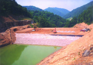
Construction of a Stage 1 dam embankment for a slurry impoundment in the bottom of a valley. (Photo: SynTerra)
Having context for the PMP helps with accurately envisioning the spillways.
Spillway designs and predictions are based on the six-hour PMP, the 24-hour PMP, sometimes the 48-hour PMP and the 72-hour PMP. “The routing for a spillway elevation gives us how much the water will rise in the pool during the discharge of that rainfall,” Campoli said. “Then, once we know that elevation, we add three more feet because that is a safety factor.”
Once you have foundation, embankment staging, slope stability and spillway details “tied down, you would actually develop the construction drawings and specifications,” Bishop said. “The specifications include a lot of detail about clearing, grubbing, soil preparation, compaction requirements for embankments, placement of internal drainage, specifications for internal drainage materials, specifications for spillway pipes and outlet channels, and specifications for monitoring the phreatic surface within the embankment as it is developed as the pool level rose.”
In a flatland impoundment, the soil under the dam is monitored from the beginning to the end of construction. In the mountains, the embankment is monitored. That action is cooked into the designs.
So are a number of predictions related to how certain types of soil will behave when moved, piled, compacted and saturated. The engineer must determine how saturated soil will behave, how it will move once the voids fill with water, action Bishop compared to the movement and behavior of a water balloon. The task of attempting to fathom the list of variables and unknowns at play could be dramatized into an Alka-Seltzer commercial.
This is where the advanced degree starts to pay for itself. The soft foundation soil of a flatland deform as the dam embankment rises. It is going to compress. The possible outcomes are numerous, with the uglier teetering towards the macabre. “If it gets loaded too quickly, and it can’t squeeze the water out, then you’ve got a shear strength problem developing that could lead to an embankment sliding,” Bishop said.
In a worst-case scenario, an embankment slide could develop with vertical and horizontal displacements, Bishop said. “If the excess core pressure was not identified as developing and construction rate kept right on moving and the embankment just kept getting higher and higher and they were not noticing from the pore pressure that their embankment was being supported by the water, then it would start moving,” Bishop said.
“And that movement could be settlement of the crest by a foot or two, shifting of the toe by several feet, or a major catastrophic failure where the whole thing just sort of melts down, particularly if it breaches into the pool,” he said.
A failure in the mountains would look somewhat different. “When you are in rock, provided you don’t have escaping of the liquified fines into an existing mine opening, the failure will be in the dam itself,” Campoli said.
There is no escaping it. The engineer must make those critical predictions about how the materials will all behave when mounting pressure, build them into the design and then rely on them as the berm goes up. “You predict what the soils are going to do based on your experience and then you have to monitor what the soil is actually doing as the wall goes up,” Campoli said. “You have got to use piezometers to measure water pressure. You’ve got to use tilt meters to see if it is sliding, because it is a prediction what these kinds of soils are going to do. If the coal company builds these things too rapidly, that is when you have a problem.”
While building the impoundment, movement sensor data is assessed regularly to ensure reality jibes with what was predicted. In a flatland dam, the piezometer in the foundation “will tell you how much water pressure there is at the critical point where you place it,” Campoli said. “The proper instrumentation will tell you about how the foundation soil is consolidating and getting rid of the water.”
There is some wiggle room. For example, being off by 4 in. over 25 ft could be acceptable. “That is where experience comes in,” Campoli said. “You’ve got to know how far away from that prediction is unsafe.”
The catch is that the SynTerra folks overdesign, Bishop later admitted, sometimes by as much as 25%. “It is a judgment call based on how much conservatism can I add to it and not put an extra cost burden on the client,” Bishop said.
Campoli described the practice as a balancing act, with the goal being to err on the side of conservatism “and still get approved by the company and the government regulators.”
Which is logical. The legal liability the contractor takes on is significant. Bishop said that if the miner designed the impoundment, built it and then managed it, they would be ultimately totally responsible. Contrarily, if the miner “hired a qualified engineer, they are probably less likely to get into trouble” in the event of a failure, he said. “The miner would not be viewed as being negligent.”
Which should offer some peace of mind to mine managers considering a new dam. The contractor also offers management and monitoring services for existing dams, which Campoli compared to house visits from a doctor.
Both said mines with upstream construction and those with aging dams should consider regularly reviewing the storm and flooding metrics on which their impoundments were designed and, if needed, make data-driven adjustments. The 100-year storm of yesteryear, fed by data from the latest nearby extreme weather event, may have shape-shifted like John Carpenter’s Thing. Or it may not have.
“For sure,” Kappel agreed. “If it is designed around, say, a 50- or 100-year event, you will want to continually look at that and make sure it is adequate and updated every two years. When you get to closure and you have to have it for the next 100 years or more, you’d want to take a more detailed look as well to be sure your closure design is adequate for what could happen.”
Because ultimately, Mother Nature is fickle. The global warming of yesterday is the climate change of today, is an ice age tomorrow. “When we are dealing with meteorology, we are dealing with uncertainty,” Kappel said. “Nobody knows for sure on all these things.”

